The rift between Laurasia and Gondwana marks one of the most significant events in Earth’s geological history, shaping the distribution of continents, oceans, and life as we know it today. This dramatic separation, driven by tectonic forces, occurred during the Mesozoic Era and played a crucial role in the formation of the Atlantic Ocean and the rearrangement of the world’s landmasses. Understanding how and why this rift formed provides insights into plate tectonics, paleogeography, and the evolutionary history of plants and animals. It also helps explain patterns in fossil records, climate changes, and the current arrangement of continents across the globe.
Background The Supercontinent Pangaea
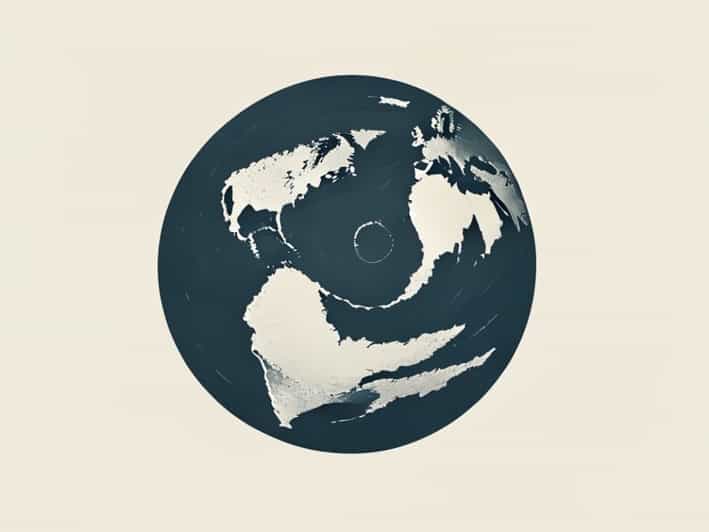
Before the rift occurred, most of the Earth’s landmasses were joined together in the supercontinent known as Pangaea. Pangaea existed during the late Paleozoic and early Mesozoic eras, forming a massive landmass that spanned almost the entire globe. The supercontinent was surrounded by a single, vast ocean called Panthalassa. The interior regions of Pangaea were characterized by extreme climates, with vast deserts and limited moisture, which influenced the evolution of terrestrial life. The arrangement of continents within Pangaea allowed for the mixing of species across regions, explaining certain similarities in fossils found today across distant continents.
Formation of Laurasia and Gondwana
As tectonic forces began to act upon Pangaea, it gradually started to break apart into two major landmasses Laurasia in the northern hemisphere and Gondwana in the southern hemisphere. Laurasia included what is now North America, Europe, and Asia, while Gondwana comprised South America, Africa, Antarctica, Australia, and the Indian subcontinent. The division of Pangaea was not sudden but occurred over millions of years, with rifting and volcanic activity gradually pushing the landmasses apart. This tectonic activity also initiated the formation of new oceans and reshaped global climate patterns.
Mechanics of the Rift Formation
The rifting between Laurasia and Gondwana was primarily driven by plate tectonics, the process by which Earth’s lithospheric plates move over the semi-fluid asthenosphere beneath them. Convection currents within the mantle caused stress along weak zones in Pangaea’s crust, leading to fractures and the gradual separation of the two massive landmasses. As the crust stretched, magma from the mantle rose to fill the gaps, forming new crust and initiating seafloor spreading. This process eventually led to the creation of the central Atlantic Ocean, which continues to expand even today.
Timing of the Rift
Geologists estimate that the initial rifting between Laurasia and Gondwana began during the early Jurassic period, approximately 200 million years ago. The separation was a gradual process, with multiple phases of rifting, faulting, and volcanism occurring over tens of millions of years. By the mid-Jurassic, the rift had created distinct ocean basins that separated the northern and southern landmasses. Evidence from paleomagnetic studies, fossil distribution, and radiometric dating helps scientists reconstruct the timing and sequence of these events, providing a detailed picture of how the continents drifted apart.
Geological Evidence of the Rift
The evidence for the rift between Laurasia and Gondwana is preserved in rock formations, fossil records, and the structure of ocean basins. Sedimentary deposits along ancient rift margins indicate the presence of lakes, rivers, and early oceanic incursions, showing that the landmasses were gradually pulled apart. Igneous rocks, such as basaltic lava flows and dikes, provide evidence of mantle upwelling and volcanic activity associated with the rifting process. Additionally, the alignment of mountain ranges and fold belts across former Pangaean margins reflects the stresses experienced during continental separation.
Fossil and Biological Evidence
The separation of Laurasia and Gondwana had profound effects on the distribution of life. Fossil evidence shows that similar species existed across the supercontinent before rifting, including early reptiles, amphibians, and plants. After the rift, species evolved independently on the northern and southern landmasses, leading to distinct faunas and floras. For example, the marsupials in Australia are thought to have evolved in isolation due to Gondwana’s separation. Similarly, the distribution of certain dinosaur species reflects the ancient connections between continents that were once part of Laurasia or Gondwana.
Climatic Implications
The breakup of Pangaea and the formation of Laurasia and Gondwana also affected global climate patterns. As the continents drifted apart, ocean currents changed, altering heat distribution across the planet. The creation of new ocean basins allowed for the development of more complex weather systems and regional climates. The interior of the continents, which had been arid during the Pangaea supercontinent phase, began to experience more varied climates due to the influence of newly formed coastlines and seas. These climatic shifts influenced plant evolution and the adaptation of terrestrial animals to new environments.
Volcanism and Seafloor Spreading
Rifting between Laurasia and Gondwana was accompanied by intense volcanic activity. Basaltic lava flows and large igneous provinces indicate that mantle plumes played a role in initiating the separation. As the seafloor spread, new oceanic crust formed, pushing the landmasses further apart and creating the early Atlantic Ocean. This combination of volcanism and plate movement had long-term effects on Earth’s geology, contributing to the formation of mountain ranges, ocean ridges, and sedimentary basins that are still evident today.
Modern Implications
The ancient rifting between Laurasia and Gondwana has left a lasting imprint on the modern world. The arrangement of continents, the distribution of mineral resources, and the patterns of biodiversity are all influenced by this geological event. Understanding the rift helps geologists predict the location of oil and gas deposits, mineral-rich regions, and aquifers. In addition, the study of ancient rifts informs our understanding of earthquake activity, volcanic risks, and ongoing plate movements that continue to shape Earth’s surface.
Scientific Importance
The rift between Laurasia and Gondwana remains a critical topic in the study of Earth sciences. It provides a natural laboratory for understanding plate tectonics, continental drift, and the interplay between geology and biology. By analyzing rock formations, fossil distributions, and paleomagnetic data, scientists can reconstruct the ancient geography of our planet and predict future tectonic trends. This knowledge also helps explain the evolutionary history of species and the development of ecosystems across the globe.
The rift between Laurasia and Gondwana represents a defining moment in Earth’s geological and biological history. Initiated by tectonic forces during the early Jurassic, the separation of these two massive landmasses reshaped the planet’s geography, influenced climate patterns, and set the stage for the evolution of life in distinct regions. Evidence from rocks, fossils, and ocean basins confirms the process and timeline of this dramatic event. Understanding the formation of the rift provides crucial insights into plate tectonics, paleogeography, and evolutionary biology, while highlighting the dynamic nature of Earth’s surface. The legacy of Laurasia and Gondwana continues to influence modern geology, biodiversity, and our understanding of the ancient forces that shaped the world as we know it today.